
Pre-1906 and 1912 De Smet Panoramic Photos
Panorama. 1, A complete or entire view in every direction. 2. A picture presenting, as from a central point, a view of objects in every direction; or a picture representing scenes too extended to be beheld at once, and so exhibited a part at a time by being unrolled and made to pass continuously before the spectator. — Webster, 1882
 C.S. McKibben, of Howard, arrived Wednesday with his family and has taken up his residence in the O.A. Taylor house just vacated by L.A. Dunklee. Mr. McKibben has purchased the Dunklee photo studio and will take possession the latter part of this week. The gentleman is an experienced and successful photographer and we hope he will find his new location all that he could desire. – Kingsbury County Independent, May 27, 1910.
WALK, FRAME, CAPTURE. Have you ever looked at an old, familiar photograph taken of a Little House town before it was a Little House museum town and, one day, you notice something in the photo that you never noticed before? This isn’t about that, but it’s leading up to it (and not even in this entry). Bear with me.
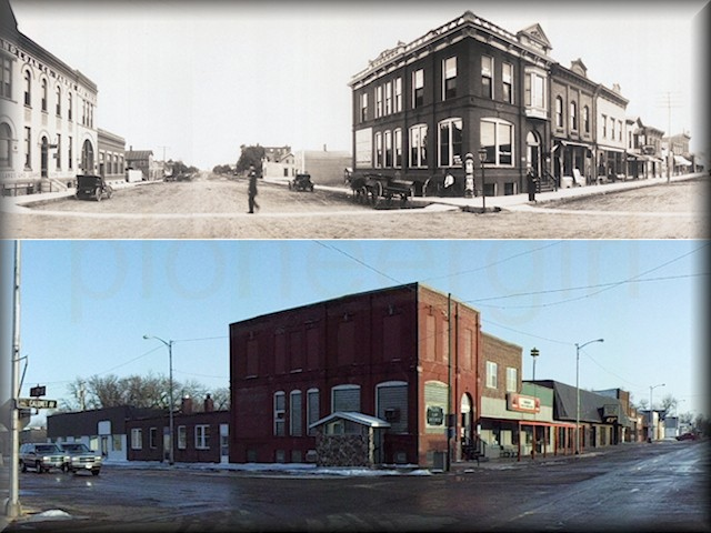
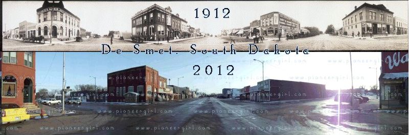
There are two well-known De Smet panoramic photographs: one was taken at the intersection of the four original town blocks (at the intersection of Calumet Avenue and Second Street) and one taken from the roof of the Kingsbury County courthouse, looking west. Both were taken in October 1912 by De Smet photographer, Clifford S. McKibben (1881-1966), using a Cirkut panoramic camera. In 1910, McKibben moved with his parents from Iowa to Howard, South Dakota, and he opened his De Smet studio that May, operating it until his retirement in 1964. McKibben is buried in the De Smet cemetery.
The Cirkut camera – first manufactured in 1904 – had a clockwork motor that was wound with a key. Once the camera was set up (shutter speed, focus, degrees to rotate, etc.), a switch on the camera engaged the motor mechanism, and two things happened. A gear meshing with the camera’s turntable base rotated the whole camera on its tripod in one direction while the same motor pulled the unexposed film in the other direction inside the camera, from its spool across the open shutter onto a take-up reel. The shutter was a vertical slit the same height as the film, and depending on the camera model, you could end up with a photograph up to 10 inches tall and up to 12 feet long, even a photo with a 360 degree view all around the camera. Contact prints were made, meaning the original paper photos developed were the same size as the negative itself.
McKibben’s two De Smet originals were roughly 6 inches tall by 4 feet wide. I don’t know if he took more than the two panoramic photos of De Smet, nor the story behind them. Maybe someone out there does and will email me. Modern prints made from the online scans can usually be found for sale online; the one taken from street level includes the former Ingalls building (where the Ingalls family lived during The Long Winter), after the building and lot had been sold to John Carroll and he had the Ingalls building moved to the alley-side of the lot and rotated it to face Second Street. Carroll’s 1886 brick bank building was then built facing Calumet. The photo taken from the courthouse roof also shows the former Ingalls building behind the bank. The former Carroll building is still standing; the Ingalls building is not.
McKibben’s 1912 Calumet Avenue original was 6×47 inches in size and can be seen HERE:
McKibben’s 1912 Courthouse photo was 6×43 inches. The former Ingalls building is just to the right of center. See that photograph HERE:
See the big cottonwood tree to the right of the center in the courthouse roof photo, behind the lighter colored house? That house (no longer standing) once belonged David Floyd, early blacksmith in De Smet, and he planted the tree in the early 1880s. When the photo was taken in 1912, it was said to be the largest cottonwood in De Smet. (The cottonwoods on Pa’s homestead weren’t in town, so they weren’t under consideration for largest tree honors.) There’s still a big old tree in that spot today (it may be an offspring); I wonder if any De Smet old-timers know anything about it? The tree Mr. Floyd set out was said to have a circumference of seven and a half feet ten feet from the ground in 1911.
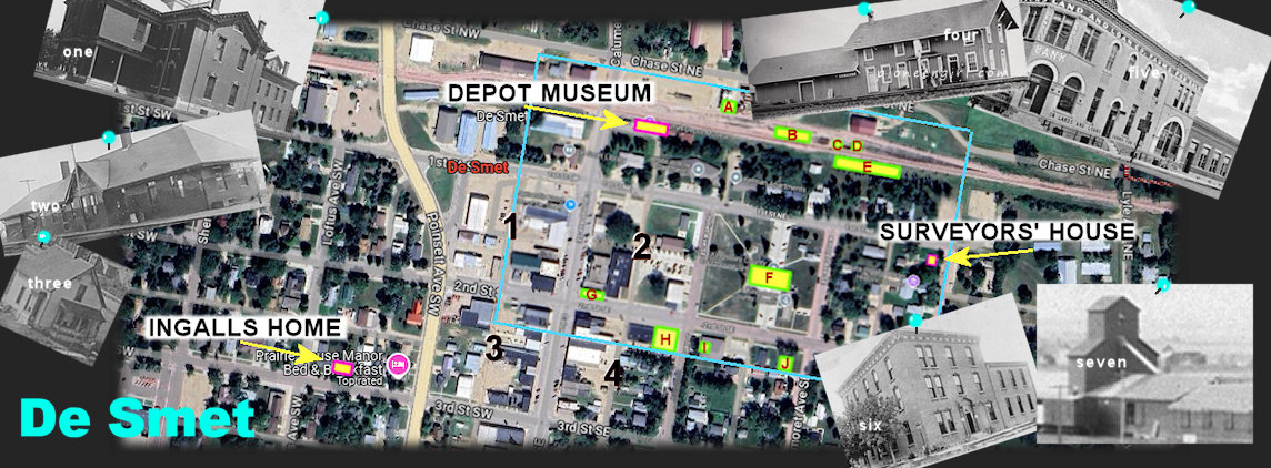
I’ve been studying some early De Smet photos the past few months – recently, of the structures or locations I’ve outlined and labeled as A-J on the bit of De Smet google aerial shown above; click on photo for larger view. Some labeled structures are still standing; some aren’t. For reference, I added labels for a few tourist spots everybody should be able to find: the Ingallses’ home on Third Street, the Depot Museum, and the Surveyors’ House. I also numbered the four blocks of the original town of De Smet.
I’ve been concentrating on buildings located inside the aqua blue rectangle on my image. There’s not anything special about that rectangle, Little House wise; that was just the original screen capture I happened to take. I’ve been pondering the following:
A. Original location, VAN DUSEN ELEVATOR (burned April 1905)
B. Original location, DE SMET DEPOT (burned April 1905)
C. WATER TANK (no longer standing)
D. WINDMILL (no longer standing)
E. COAL HOUSE (no longer standing – Although an early coal house was moved from near the railroad tracks to a location east of the Super Deluxe Inn & Suites, the coal house behind the motel was from one of the mills west of Calumet, not the one used at the old depot.)
F. KINGSBURY COUNTY COURT HOUSE (202 2nd St. SE)
G. WATERS LAND & LOAN (now Heritage House Bed & Breakfast, 126 Calumet Ave.)
H. SYNDICATE HOTEL (torn down in 1991)
I. Former CARRIE & CHARLES ELY HOUSE (no longer standing) – Mr. Ely was an early lumberyard owner.
J. Former GEORGE LATTIN HOUSE (still standing, private residence) – Mr. Lattin was editor of the Kingsbury County Independent.
Old photos of some of the buildings I’ve been studying are pinned around the edges of my composite above. How many do you recognize?
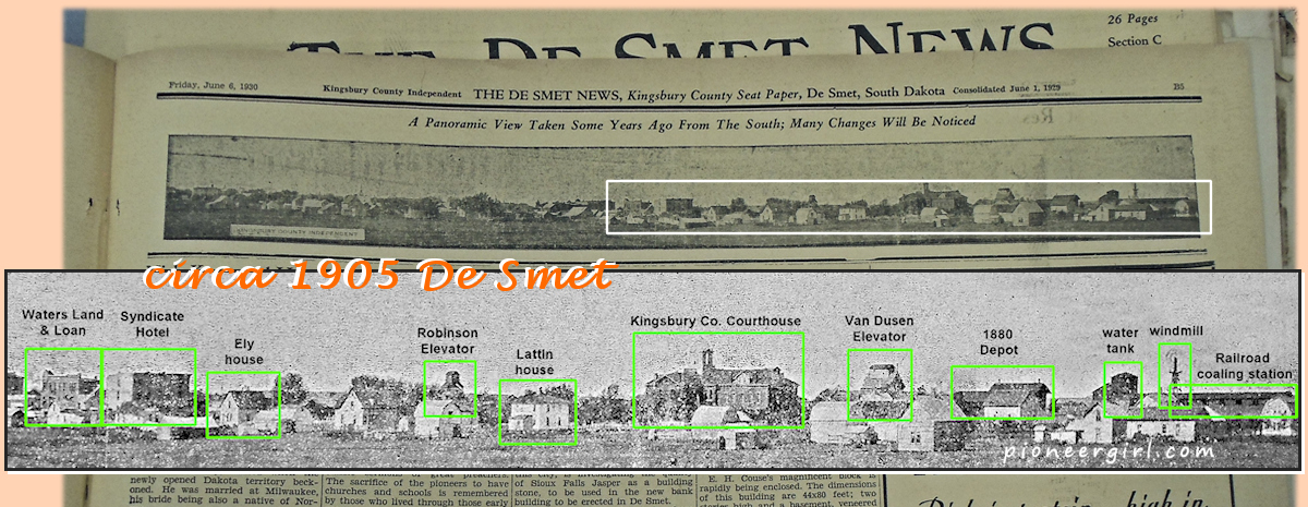
The De Smet News (50th anniversary issue, June 6, 1930) includes a page-width Kingsbury County Independent photo with the caption: A Panoramic View Taken Some Years Ago From The South: Many Changes Will Be Noticed. Maybe copies of the actual photograph are still framed and on display in houses all over De Smet, but this one issue of this one newspaper is the only place I’ve ever seen it. Does an original print exist? Does the negative exist? Who took the original panoramic photograph, and when?
Was the “view from the south” photo taken with a Cirkut camera like C.S. McKibben used? There were other panoramic cameras in use in the early 1900s, among them the 1898 Al-Vista and the 1899 Kodak Panoram, both of which were swing-lens cameras that didn’t need a tripod (because just the lens rotated, not the whole camera), so they didn’t require the knowledge to use or and they both cost less that the Cirkut. You could send their film off to be developed, making it popular with amateur photographers who wanted to take pretty pictures and not have to develop film themselves.
These cameras produced small panoramas no more than 12 inches in length. Panoram photos were often pieced together to make longer images; the Al-Vista took one short, long photo with a field of view of almost 180 degrees. Having never seen an original of the “view from the south” photograph, I have no clue about the camera used, but one thing is certain: it wasn’t taken by Clifford McKibben, who didn’t move to South Dakota until 1910. Considering that the McKibben photos were 6 inches tall using a Crikut, if this photo as it appeared in the paper was 6 inches tall as well, it would be over 60 inches wide.
The south view definitely dates to 1905 or earlier for the pretty exciting reason that it includes the original Van Dusen elevator and the original 1880 depot that both burned down in April 1905. I’ve written about the depot tintype before, and now here’s a second depot photo.
I identified some of the buildings / structures from the right half of the photo on my enhanced image above. The photo was taken southeast of the intersection of 2nd St. SE and Amoret Avenue. The depot is the building with two chimneys behind the house that’s closer to the camera (darn it), and the Van Dusen elevator is just to its west. The railroad water tank, windmill, and coal house are east of the depot, and if you look closely at the windmill, you can tell by the blur that the blades were spinning when the photo was taken.
If you’ve ever heard anything about where the depot stood from 1880 – 1905, it’s described as being “due north of the courthouse, on the other side of the tracks” from where the second depot (now the Depot Museum) was built in 1906. On the map I posted earlier in this entry, I showed the location of buildings because they’re in this photo. How can the depot that was “due north” of the courthouse show up so far to the east of it in this photo? It’s because of where the photographer was standing and the nature of panoramic photos… and math.
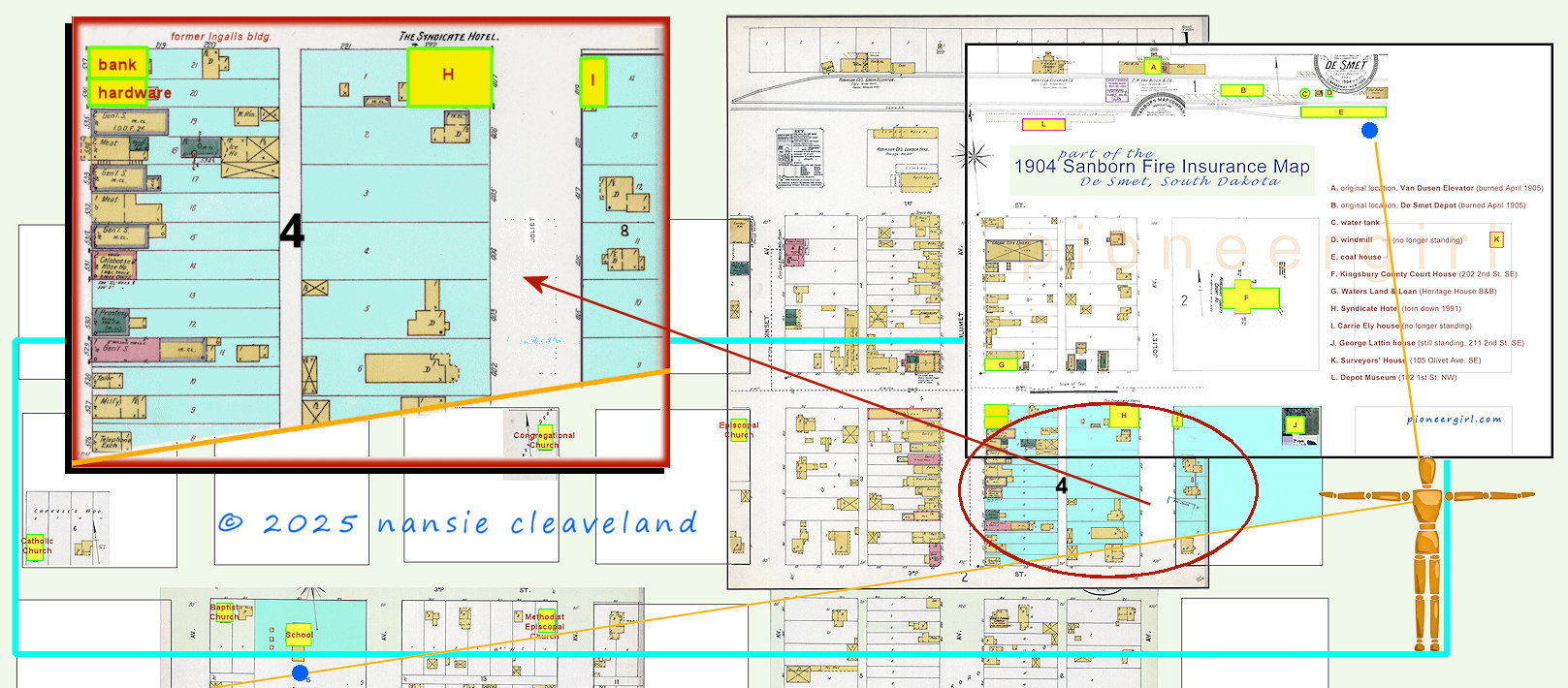
PART OF THE 1904 SANBORN FIRE INSURANCE MAP FOR DE SMET — A link to the two full pages of the 1904 fire map is below. The image above is of a portion of the fire map that includes Block 2 and part of Block 4; click for larger view. I added the courthouse block and the one with the Surveyors’ House (and the two blocks to the south of them) by referencing current maps and later fire maps; these were not shown with the four original town blocks on the 1904 map. The original depot is on the 1904 map because that map dates from before the fire that destroyed the original depot, but I added the 1906 depot (and platform) from the 1911 map because that depot is still standing. You can see that the original depot (B) was indeed due north of the courthouse (F).
1904 Sanborn Fire Maps for De Smet SD are HERE.
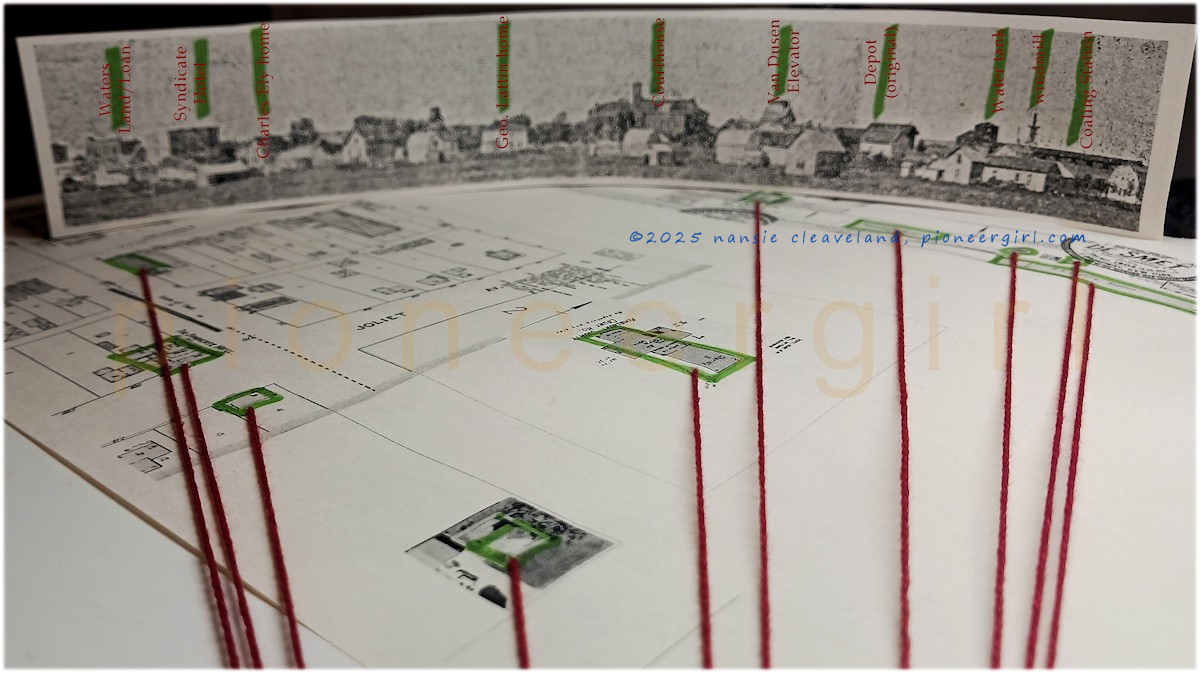
I had to get creative in order to explain to someone that the buildings shown would line up the way they did in the photo. Not knowing exactly where the photographer was standing, I relied on the buildings themselves to determine this by printing out my modified 1904 Sanborn map and taping it to a board (suggesting ground level). Then a print-out of the portion of the panoramic photo that included buildings in the four original blocks to the west and the depot and outbuildings to the east was lined up with their flat-map counterparts in a curve and taped in place. Attaching a piece of string to the “camera side” of each building, I gathering the strings in a bundle without any strings crossing. Where all strings converged at a single point showed that the photographer was standing somewhere on Block 9, Western Town Lots Co.’s Addition to De Smet or on Amoret Ave. beside it, with the camera centered on the southeast corner of George Lattin’s house. Remember that this was a photograph credited to the Kingsbury County Independent, and that George Lattin was the one who started the newspaper and was its first editor. It makes sense that he would want his own house front and center!
The original pre-1906 panoramic photo captures an arc from the coal house on the eastern side of the depot to the 1885 schoolhouse 90 degrees to the west. The schoolhouse is farther away from the photographer than the coal house. Some of the houses between the photographer and the railroad buildings are closer to him or her than the Lattin house on 2nd St. (still standing), but I haven’t looked at deeds yet to identify who owned all of them at the time.
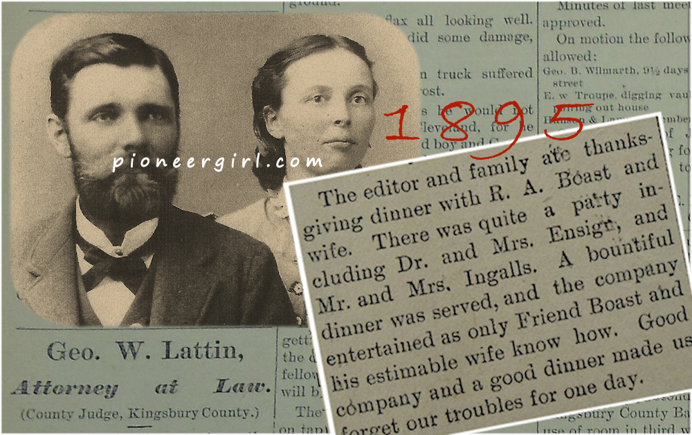 George William Lattin (1858-1932) was a Kingsbury County attorney, county judge, and Captain of Company E, 1st South Dakota Volunteer Infantry during the Spanish-American War. As publisher of the Kingsbury County Independent, Lattin was originally in partnership with Elisha O. Bennett (printer and the father of Will Bennett, the young lad who may have inspired the personality of Laura Ingalls Wilder’s book character, Willie Oleson). When Bennett left the newspaper in 1894, Fred Wright of the Volga Tribune came to run the press. (Harvey Dunn painted a portrait of Fred Wright on a visit to De Smet.)
Wright temporarily took over as editor of the Independent in 1896 when Lattin was obliged to go with the rest of Co. E. to the Philippines as Captain, because George Masters (who would have been Captain), failed his physical examination and wasn’t allowed to serve. At some point after his discharge in 1899, Lattin sold the newspaper to Fred Wright and concentrated on his legal and political career in De Smet, moving to Nevada in 1909.
In 1929, the Kingsbury County Independent consolidated with The De Smet News, which is why Aubrey Sherwood had access to KCI photos to use in his 50th anniversary edition.

De Smet panoramic photos See also: Great video of a guy developing a Cirkut panoramic photo HERE; De Smet Depot; Syndicate Hotel; Alfred Waters; Wilder Feed Store (for info about another panoramic photograph)