
Verdigris River
A tributary of the Arkansas River in southeastern Kansas and northeastern Oklahoma in the United States. — Webster, 1882
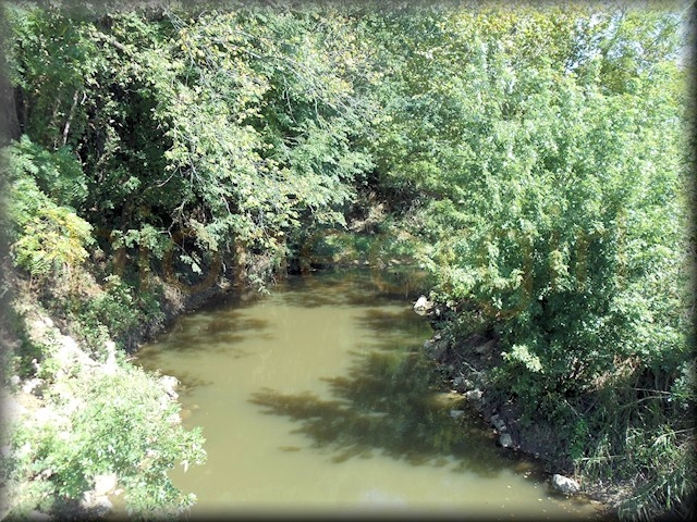
 The Verdigris is a deep, narrow stream. The banks are steep and high. It affords water enough in an ordinary season to turn machinery. The bottoms above the mouth of Fall river are quite narrow, but rich. The hills rise up abruptly, and are sometimes covered with sandstones, black jacks and post oaks. There are a great many beautiful mounds along its whole course. It ought to be called Mound River. The soil at the base of these mounds is good. In a late trip down this river, I passed through, or near, the following towns: Coyville, Guilford, Altoona, Verdi, Neodesha, Independence, Liberty, Clymore, Westralia, Parkersburg, and Coffeyville. Towns enough for one little river. The most of them are new, and a good number propose to be county seats. Some of them will die. Two of them may be county seats. Elk river heads up near the western line of Howard county, and runs almost east through that and Montgomery county, emptying into the Verdigris two miles above Independence. The appearance of the stream and the country around it are very mush like that described above. There are not so many towns, but the country is filling up fast. – The Emporia News (Emporia, Kansas), December 24, 1869.
 In Little House on the Prairie (see Chapter 5, “The House on the Prairie”), the Ingallses hop out of the wagon and Pa tells the family that “right here” is where they’ll build their house. They were surrounded by grassy prairie spreading to the edge of the sky. Quite near to the north were creek bottoms, and far away to the east, they could see “a broken line of different greens [that] lay on the prairie, and Pa said that was the river. “That’s the Verdigris River,” he said, pointing it out to Ma.
The Verdigris River is twelve miles east of the Little House on the Prairie Museum. Because of the curvature of the earth, the average person can see about 3 miles in the distance on a clear day. The LHOP cabin is at the same elevation as land on the west river bank of the Verdigris, so even accounting for no trees except for any at the river, you’d have to be 80 feet above ground in order to see the river. If the trees at the Verdigris were over 80 feet, that does suggest something was visible on the horizon. The only problem with this is that Onion Creek was between the LHOP site and the Verdigris. It also had trees, and it’s only 2.5 miles east of the LHOP site, or well within the sight of the LHOP cabin. Any trees along Onion Creek would have no doubt blocked those along the river another ten miles to the east.
CLICK HERE to see via Google Earth a starting point at the Verdigris River in Liberty Township in Montgomery County, looking west towards Wayside, Kansas, (which should be labeled at the top of your screen), two miles west of the LHOP Museum and replica cabin. The road you see is Montgomery County Rd 3000. It’s fun to scroll west from the river (towards the top of your screen); 3000 Rd becomes Laura Ingalls Wilder Highway where it picks up across Onion Creek, and a pin for the LHOP Museum site will appear once you get close. Scroll slowly so you don’t miss Onion Creek.
 In Wilder’s handwritten manuscript that became Little House on the Prairie, there’s no mention of the Verdigris River by name. She begins the story with the Ingalls family near Independence, Kansas, with Pa having received directions to the river ford. The harrowing high-water crossing is as described in published Little House on the Prairie. It’s widely accepted that Wilder was writing about crossing the Verdigris River, but if the Ingallses had already stopped in Independence, they would have crossed the river in order to get there, not when heading to the southwest where the cabin site was.
It’s unknown where the Ingallses may have crossed the Verdigris River, but an early well-known ford in Independence was known as Brown’s Ford, and it was located where East Myrtle Street meets North Burns Street. A bridge was later built over the Verdigris at this spot (the ruins of a bridge are still there). The ford is shown here in an early postcard view. In May 1871, four wrought iron bridges over the Verdigris were contracted for and would be built as son as possible: one over the Verdigris at Parker, one at Liberty, one at Independence, and one over the Elk River at Elk City, at a total cost of almost $30,000. Shortly after the Ingallses left Kansas, there was a ferry also in operation during times of high water. In early 1869, travelers in the area reported that when they left Independence, they “crossed the Verdigris by a very difficult ford– banks very steep and soft… [It was] nearly impassable, especially for loaded teams. We do not believe it speaks too well for the flourishing town of Independence…” (Girard Press, Girard, Kansas)
As reported by the South Kansas Tribune (an Independence newspaper) in July 1871, the Verdigris was said to have a heavy volume of water and a very swift and strong current. When visitors forded, the water ran freely through the bed of the coach. Wilder paints a vivid picture of such a crossing in Little House on the Prairie.
The Verdigris River was named by French traders in the early 18th century for its greenish-gray hue similar to that of copper ore. It begins near Madison in Greenwood County where the North Branch Verdigris River and South Branch Verdigris River converge. It was said to be the “crookedest stream in the State,” flowing through Wilson County before entering Montgomery County in Section 4, Township 31 South, Range 16 East. It is the current line between Sycamore township (to the west) and West Cherry Township (to the east). The river leaves Montgomery County in Cherokee Township, Section 18, Township 35 South, Range 17 East. There was heavy timber on either side of the river, ranging from one to four miles wide, while seven tributaries were living streams with a fine growth of walnut, hickory, oak, and sycamore.
Because a legal survey of Montgomery County section lines wasn’t conducted until May 1871, early maps either don’t show the Verdigris River through unsurveyed land, or it’s not depicted at all accurately. The map portions below are from Library of Congress maps: from left to right are 1870 Rufus Blanchard Sectional Map of Kansas, 1870 New Railroad & Sectional Map of Kansas by E.H. Ross of St. Louis, 1870 Johnson’s Kansas and Nebraska Map by A.J. Johnson of New York, and 1881 Historical Atlas of Montgomery County Kansas, by John P. Edwards of Philadelphia. On the last map, the Verdigris River has been colored blue, and a star is placed where the Little House on the Prairie Museum is located in Section 36 of Rutland Township, believed to be the site of the Ingallses’ cabin. Click HERE to open this map (with links to other pages of the atlas) in a new window.


Verdigris River (LHP 5, 19, 25; SSL 9, 19; TLW 11, 18; THGY 25, 32)