
Silver Lake

Forty-five acre prairie pothole lake near De Smet, in Kingsbury County, South Dakota.
 Silver Lake affords excellent recreation and anyone who can muster a pair of skates takes advantage of the fine moonlit evenings to indulge in the exhilarating sport, regardless of zero weather. – November 17, 1883, De Smet Leader
 Silver Lake was formed by retreating glaciers thousands of years ago, a glacial kettle formed by gouging, shifting ice masses that settled into the earth. When the ice melted, a prairie pothole was formed, a fairly shallow depression that could fill with water. The water level in a pothole lake is always dependent on rainfall, snow melt, runoff, and other aspects of water availability.
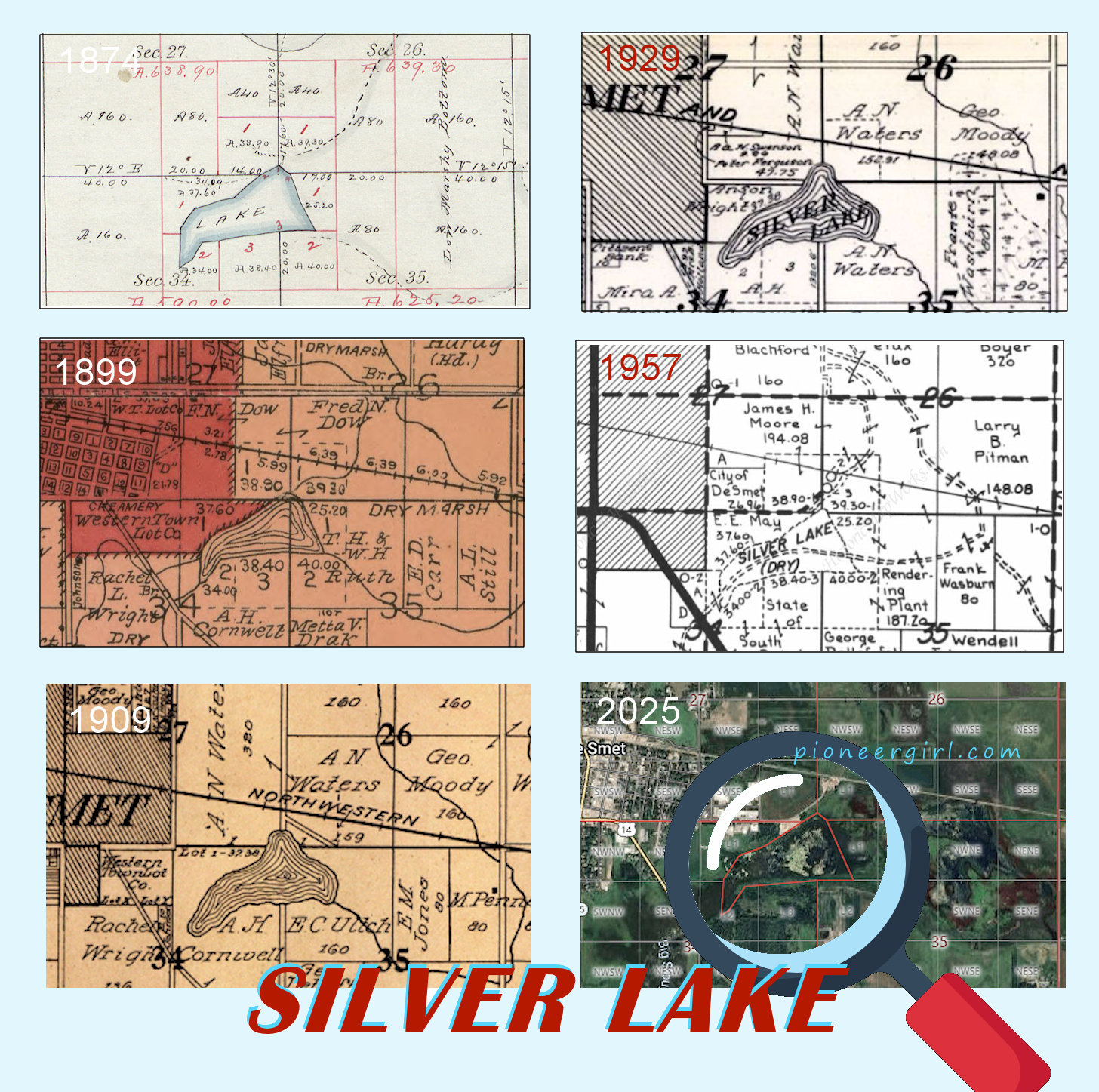
Silver Lake lies between the Big Slough to the southwest and the marshy bog that became known as Penney’s Slough to the east. At the time of the 1873-1874 original survey of the area, the lake covered 66.6 acres of land; a portion of the survey is shown at right, with the railroad tracks, Big Slough, and original four blocks of De Smet added for reference. Ingalls Homestead / Charles Ingalls’ homestead claim (NE 3-110-56) is a mile to the south of Silver Lake, and Highway 14 crosses the junction of Silver Lake and the Big Slough, the spot where Charles Ingalls crossed when walking to town from the homestead.
When the railroad was being surveyed through Kingsbury County in 1879, it was hoped that the town in that section could be platted near the lake with residential blocks near the shoreline, so the Surveyors’ House was built on the right-of-way just to the north of Silver Lake. Steam engines needed water the lake could provide. That quarter section had already been filed on by Fred Dow as a tree claim, however, and he wasn’t about to give it up. Dow said that when he came to the area and saw the waters of Silver Lake shining in the sun, he decided that was where he wanted to file; he wrote that in his 1100 miles of traveling that year he had seen nothing like it. [De Smet News, June 6, 1930.] Even threats from the railroad that they would locate the town miles away didn’t persuade him to give up his land for the townsite, so the four original blocks of De Smet were platted a half mile to the west.
During the Little House years, there was enough rainfall and snow-melt to keep Silver Lake full of water. In the winter, it was a popular spot for ice skating, just as Carrie and Laura had enjoyed sliding there while living in the Surveyors’ House. In the 1880s, there was a campaign to create a city park around the lake, residents believing that the “miniature lake could be made most attractive at very little expense,” according to Jake Hopp in the Kingsbury County News. Hopp even stated that he didn’t want to see the area become a dumping ground, but rather an advertisement for the town and a blessing for future generations. As De Smet grew in size, the western shoreline was included in the city limits of De Smet.
But then, beginning in 1893, Silver Lake – although still a pothole lake – almost dried up. Just as Rose Wilder Lane wrote in her introduction to On the Way Home, “there had been too little rain.” The lake was nothing more than “mud and dry bank” until melting snow overdid it in 1897, and Silver Lake not only filled up, but left the adjoining slough six feet under water and covered the railroad tracks east of town. For the next ten years, Silver Lake was again a popular place to skate in the winter and hunt in season, but many residents looked at Silver Lake not for its beauty, but for the nuisance it became when it overflowed its banks. They also noted the acres and acres of arable land it could become, if only it could be made to stay dry. As part of the natural Lake Thompson watershed, excess water (from rain or snow melt) always flowed from the Big Slough into Silver Lake, and the lake’s overflow could temporarily spread out to cover 200 acres or more, but the footprint of Silver Lake proper didn’t change once the water receded and the lake wasn’t spilling over its banks. It went back to being a “pretty little lake” that covered parts of a half section in size, as maps throughout the years show. (Click image below for full-size)
The lake wasn’t always recognizable as a lake over the years, but sloughs adjacent to the lake were typically always too wet to plow and valueless for crops except for the hay that could be harvested there. In 1910, the decision was made to dig a ditch through the center of the marsh slough and the Penney farm in Section 36, and to dig all the way to Lake Henry if possible, thus permanently draining the water out of the prairie pothole, which would then be filled in. The initial project seems to have been abandoned after the lake filled up again in 1914. After World War I, however, the Silver Lake drainage project again made the news:
 EXTENSIVE DITCHING WILL IMPROVE LAND. Silver Lake to be Drained and Land Reclaimed. Property Owners Unite in Contracting for Several Miles of New Ditch.
Some extensive ditching is being done in this vicinity that will mean the reclaiming of many acres of land adjacent to De Smet.
Anson Wright, A.N. Waters and the county are all interested in the project and there will be several miles of ditch.
The contract for the ditch was let to E.D. Flannagan of Huron and the work is being done by Jorgenson & Elwell. The machine used is a capstan ditcher operated by horse power. The machine is pulled by two heavy cables and is twenty to thirty rods behind the capstan. It moves at a snail’s pace, but behind it is a ditch three feet deep, eight feet wide at the top and sixteen inches at the bottom. Once thru does the business, and the ditch needs no further attention as the sides slope enough to prevent caving. Slow as the machine moves it is possible to cover as high as eighty rods in a day, depending on the condition.
The ditch starts east of the road leading south from De Smet and south of the Geo. A. Smith place. This line runs east to the east end of the grade beyond the creamery. A branch starts a short distance south of the creamery and joins the main line. A new culvert will be put in across the grade and the ditch continued the entire length of Silver Lake and on to connect with a ditch put thru several years ago leading toward Lake Henry. This old ditch is to be cleaned out and made more serviceable.
The ditching will clean up a large tract of land that has been of little use. It will entirely drain Silver Lake, and while it may be a long time before all the land is made tillable, it will turn the wet marsh into hay and pasture land, and the outlay is justified.
Another benefit will be the draining of water from along the grades south and southeast of town and save the expense of continually adding dirt and gravel to them to keep the roads passable. – De Smet News, August 24, 1923

Aerial photography from the 1950s shows the location of ditches dug in hopes of draining Silver Lake into Lake Henry to the south.
The Commercial Club of De Smet had for years wanted to make De Smet the “cleanest, neatest city in the state,” and about the same time as the ditching, Edward Couse launched a city-wide clean-up campaign. The town garbage dump then in use just northwest of De Smet and it was an eyesore as well as visible from passing trains, so Silver Lake became the new town dump.  The February 24, 1924 De Smet News reported that Silver Lake was an ideal dumping ground, being out of sight from all roads and houses. It was near the outlet of the new sewer’s disposal pipe, and the old bed of the mostly dry lake could gradually be filled up with refuse. But the dust bowl years filled in many of the ditches and Silver Lake simply went on as it always had, its water level changing due to rainfall, snow melt, runoff, and other aspects of water availability. It was still in use as a dumping ground well into the 1960s, and Little House tourists were disappointed to discover how the beautiful body of water described in By the Shores of Silver Lake had been treated.
Not even being told by Museum tour guides through the 1990s that Silver Lake had been drained in the 1920s and no longer existed so there was no need to go looking for it could stop some visitors from seeking out old maps and hunting for the location of Silver Lake for themselves. It’s still a beautiful place, and the original 45 acres are clearly discernible in online aerial photographs, although some of it is now more slough than lake, thanks to organic matter building up over the decades. No matter what the season, it’s easy to see why Laura loved Silver Lake. The easiest way to view Silver Lake today is to drive east on 4th Street, S.E. Once you pass O’Keefe Steet on your left and round the curve and head northward towards the railroad tracks, you’ll see the lake to your east. It may not be a smooth sheet of water all the time, but it’s still beautiful, don’t you think?


Compare the size of Silver Lake on the 1899 atlas, the 1950 aerial and 2020 (c) Google aerial to the original survey drawing to see just how little the size and shape of Silver Lake has changed over the years!

Silver Lake (SSL title, 7-8, 10-13, 16-17, 19, 22, 25-29; TLW 6, 14, 18, 31; LTP 7; THGY 13, 19-20, 32; PG) – Click HERE to read some newspaper bits about Silver Lake. The document will open in a new tab or window.
banks of Silver Lake (TLW 18)
Silver Lake Camp (SSL 7, 9-10)